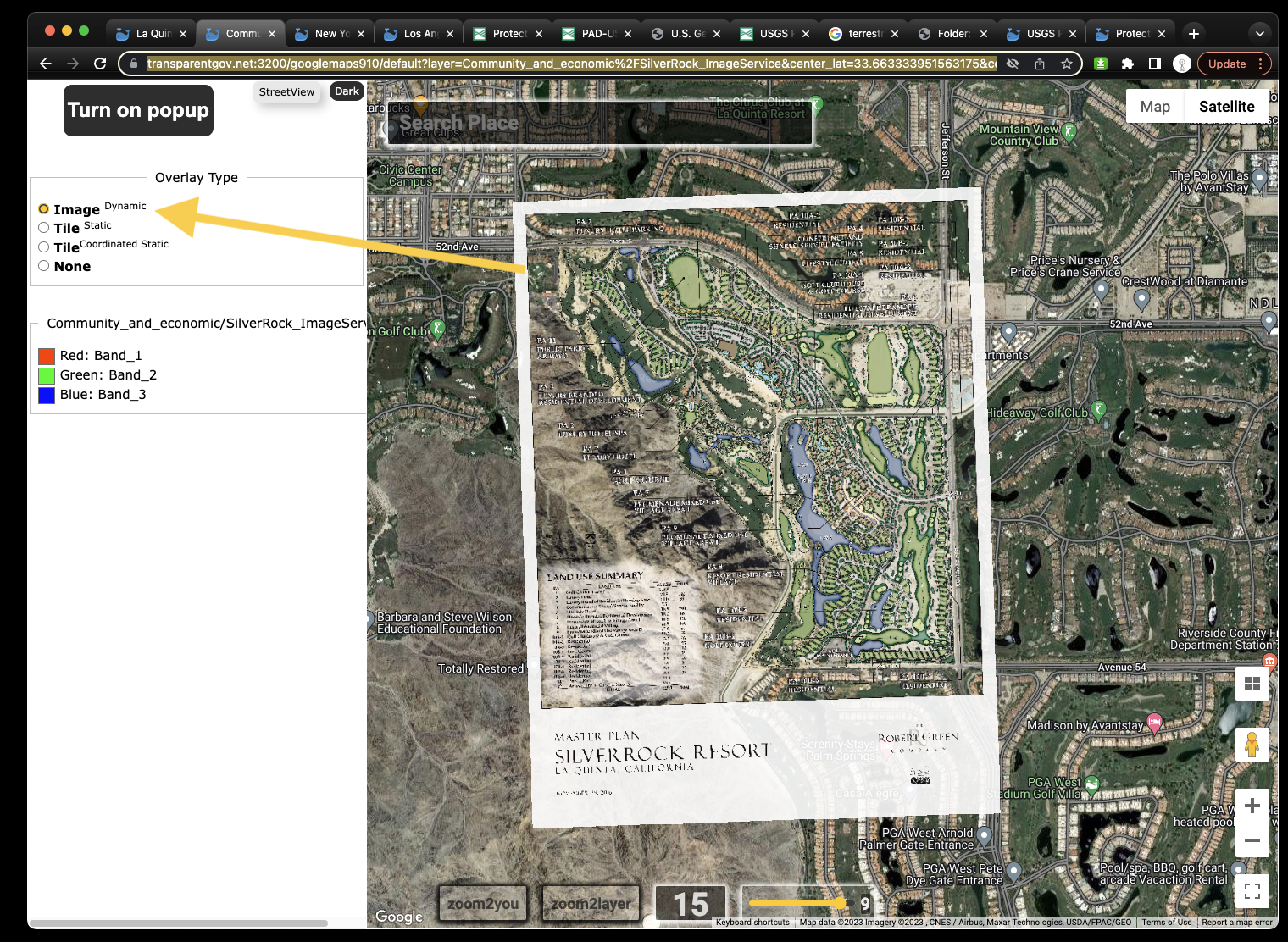
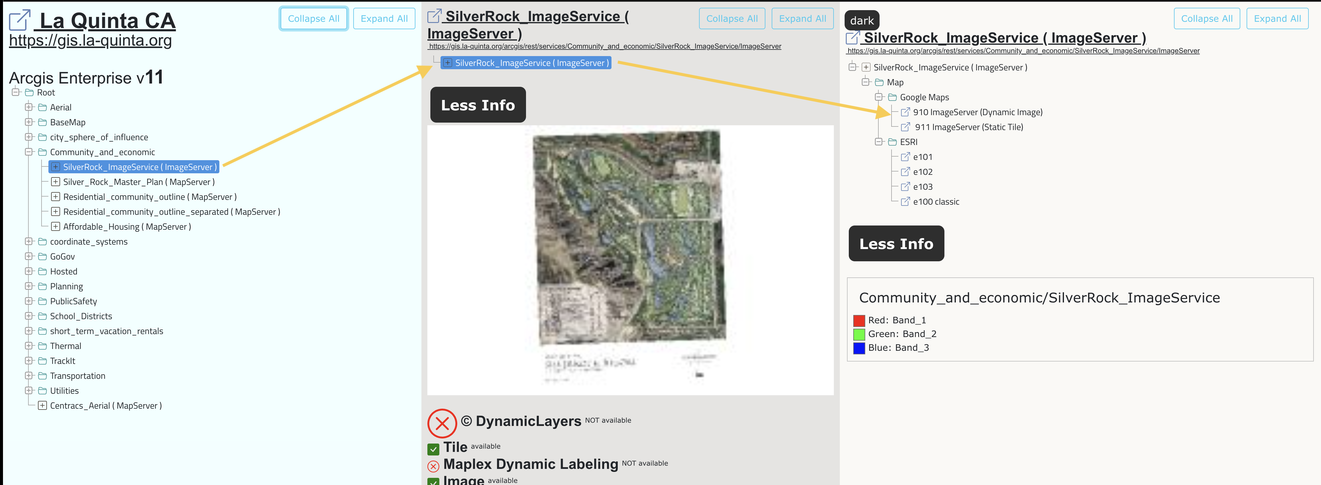
910 ImageServer + dynamic image
https://transparentgov.net:3200/googlemaps910/default?layer=Community_and_economic%2FSilverRock_ImageService¢er_lat=33.663333951563175¢er_long=-116.2748473566695¢er_zoom=15&url=https%3A%2F%2Fgis.la-quinta.org%2Farcgis%2Frest%2Fservices%2FCommunity_and_economic%2FSilverRock_ImageService%2FImageServer&overlayType=overlayType_image&panto=0
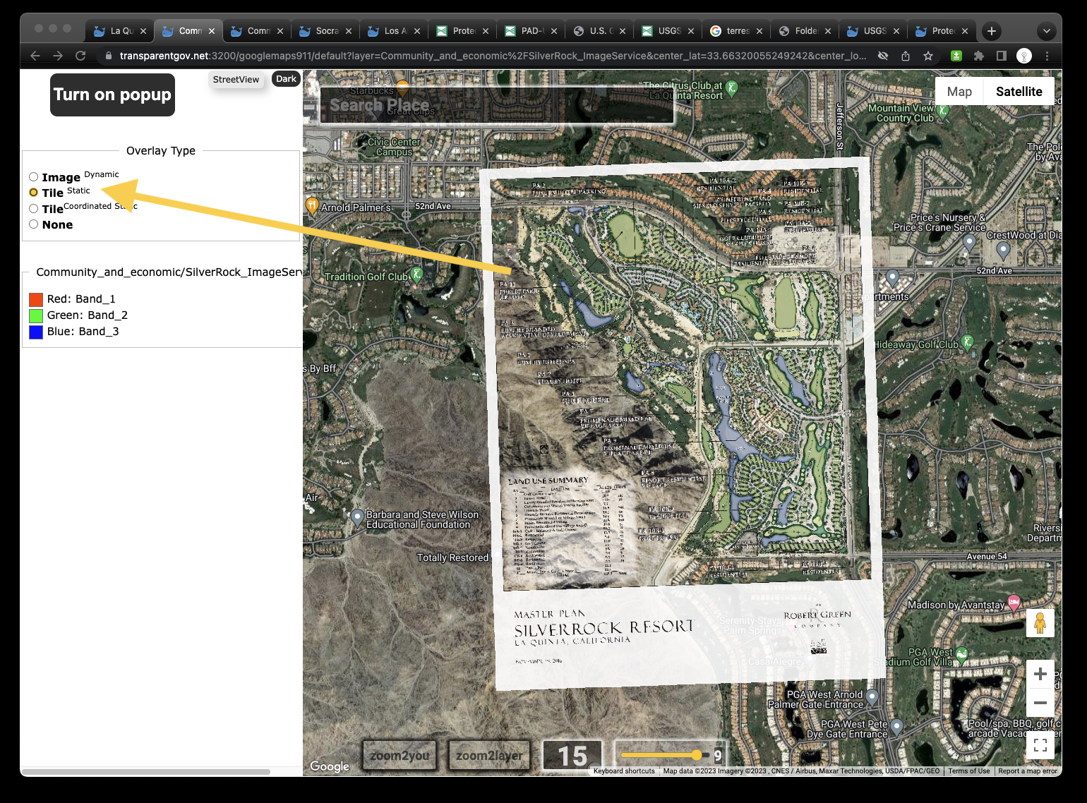
911 ImageServer + static tile
https://transparentgov.net:3200/googlemaps911/default?layer=Community_and_economic%2FSilverRock_ImageService¢er_lat=33.66320055249242¢er_long=-116.27817757394348¢er_zoom=15&url=https%3A%2F%2Fgis.la-quinta.org%2Farcgis%2Frest%2Fservices%2FCommunity_and_economic%2FSilverRock_ImageService%2FImageServer&overlayType=overlayType_tile&panto=0
https://transparentgov.net/json2tree/esri/server2/folder.html?url=https%3A%2F%2Fgis.la-quinta.org%2Farcgis%2Frest%2Fservices&org=La+Quinta+CA&select_folder=62&select_layer=-1
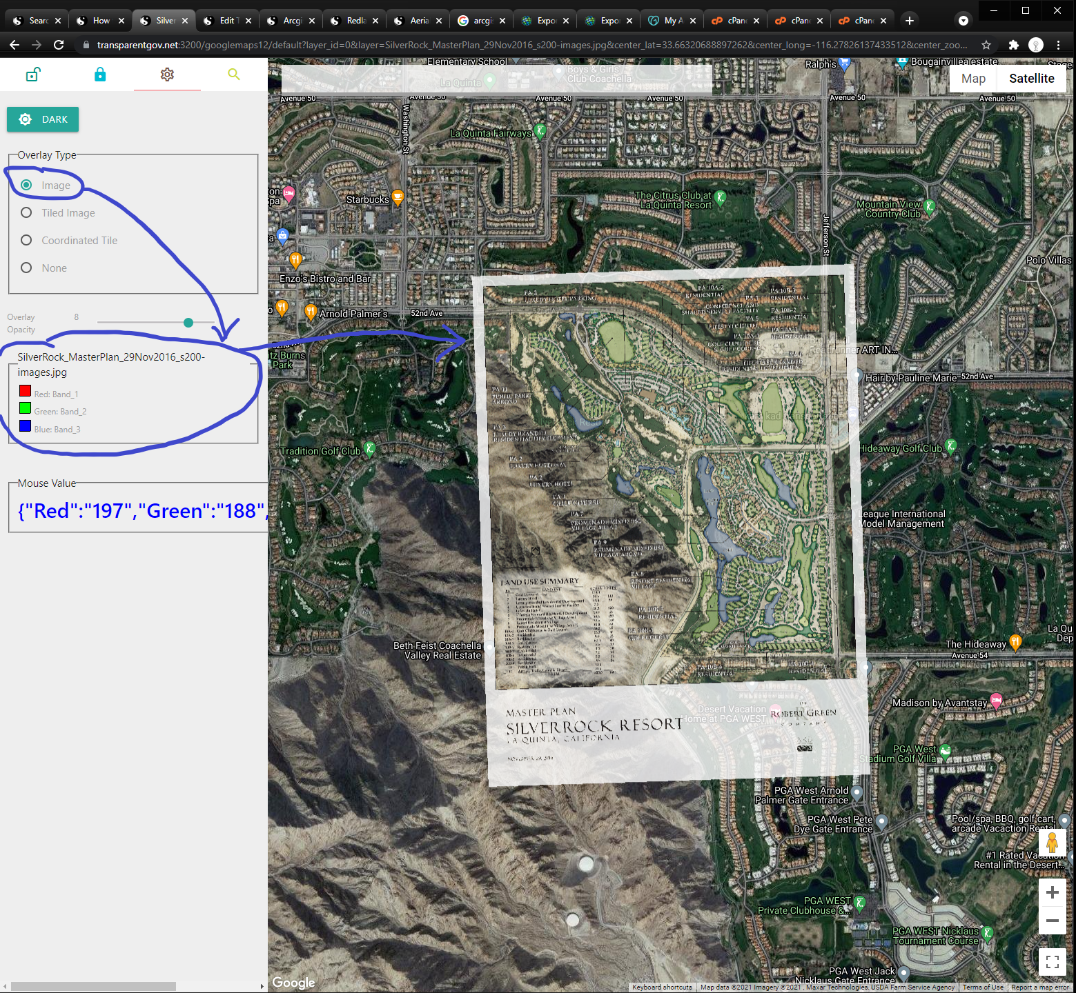
Why we need georeferencing image?
The future development plan map have planning information that is not exist on earth yet. The building has not been build yet, it is not on google satellite imagery, but we still want to see how it will fit into current environment.
For example, this golf court resort development plan was georefenced on google map. If you turn off the development plan map, you will find there is no construction yet on google satellite image.
https://transparentgov.net:3200/googlemaps12/default?layer_id=0&layer=SilverRock_MasterPlan_29Nov2016_s200-images.jpg¢er_lat=33.66320688897262¢er_long=-116.27826137433512¢er_zoom=15&url=https%3A%2F%2Fgis.la-quinta.org%2Farcgis%2Frest%2Fservices%2FCommunity_and_economic%2FSilver_Rock_Master_Plan%2FMapServer&panto=0&overlayOpacity=8&overlayType=overlayType_image
Using georeference tool in ArcMap, by add 2 control point, you can georeference jpg. To save the coordinate projection information for your jpg, ArcMap provide you 2 ways :
Above example use "update georeference" option, when you choose "update georeference" from drop down menu of georeference tool bar, ArcMap create 2 more file that has coordinate projection information for your jpg.
Below example use "rectify" option, when you choose "rectify" from drop down menu of georeference tool bar, a dialog window pop-up, ask you where do you want to save the new generated raster image. So ArcMap will re-create a new raster image which has spatial information that you just georeferenced.
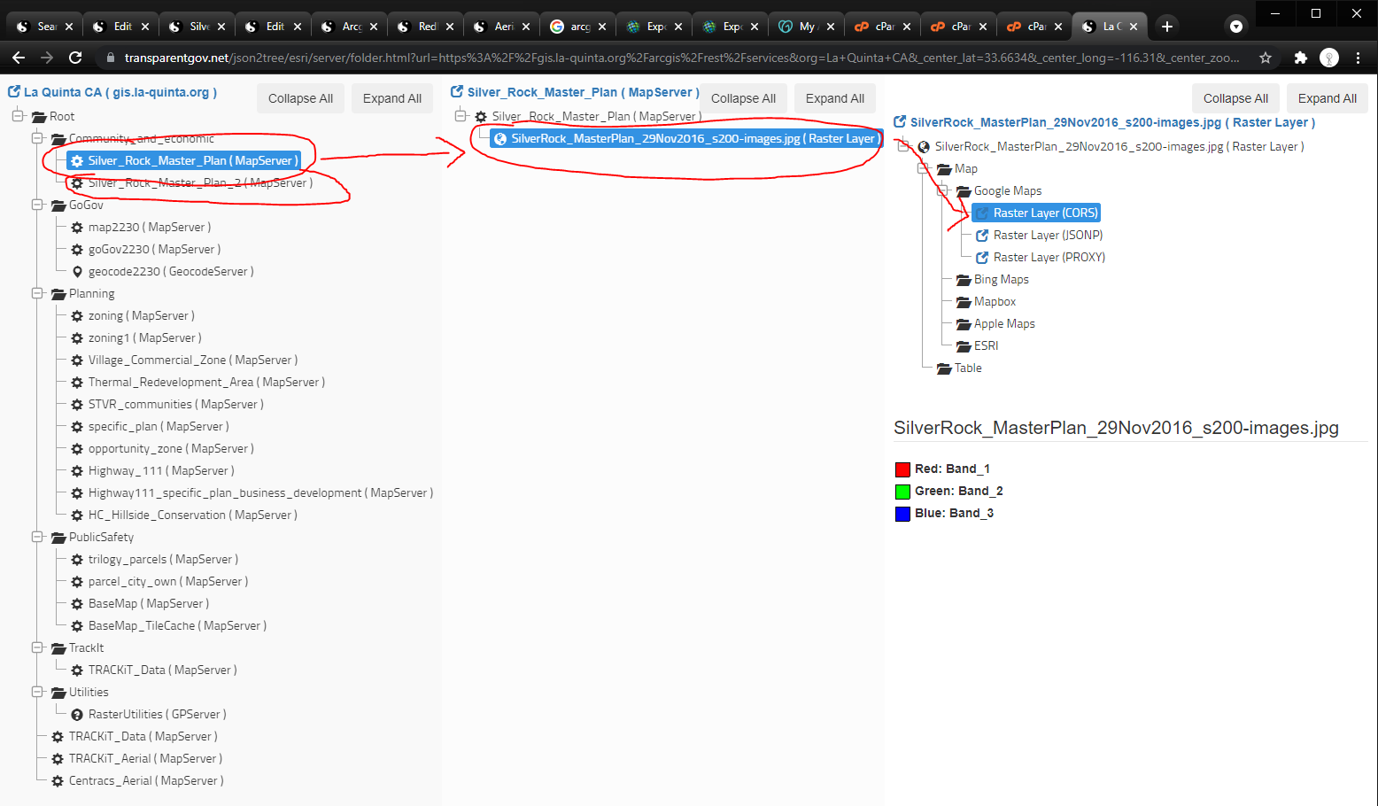
https://transparentgov.net:3200/googlemaps12/default?layer_id=0&layer=SilverRock_MasterPlan¢er_lat=33.66320441143618¢er_long=-116.27818939152095¢er_zoom=17&url=https%3A%2F%2Fgis.la-quinta.org%2Farcgis%2Frest%2Fservices%2FCommunity_and_economic%2FSilver_Rock_Master_Plan_2%2FMapServer&panto=0
https://transparentgov.net/json2tree/esri/server/folder.html?url=https%3A%2F%2Fgis.la-quinta.org%2Farcgis%2Frest%2Fservices&org=La+Quinta+CA&_center_lat=33.6634&_center_long=-116.31&_center_zoom=17&select_folder=29&select_layer=0
Silver Rock Master Plan using option 1, add spatial georeferencing information to 2 extra file along with original JPG file.
Silver Rock Master Plan 2 using option 2, generate a completely new raster file which has georeferencing information.