problem
county assessor office publish address format comply USPS postal address standard. Street number and street name and street type are in one field.
However, 911 dispatch data use esri network analysis product. It require street number and street name and street type in seperated fields.
County's street center line also have same problem. POI also have same problem. They are all in USPS postal address standard.
When prepare 911 dispatch database, all layers's address all need to split into component.
Option 1.
Buy Arcgis Pro (5k-50k/yr) + 6 months training on how to use ArcPro, details
https://transparentgov.net/cleargov1/1771/how-split-street-name-into-fields-for-911-without-esri-license?show=1771#q1771
Option 2.
Install free QGIS + 6 months training on how to use Qgis, details
https://transparentgov.net/cleargov1/1814/how-to-splite-street-name?show=1814#q1814
Option 3.
99% of general public user don't have money for option 1. to buy esri license.
99% of general public user don't have time for training at option 1 and option 2.
Even Qgis is free, but no time to install and learn.
split address becomes privilege only for a few gis staffs in city employee.
Even police officer, 911 dispatcher, don't have access to these functions.
Now model 6803 and 7455 give 99% of general public user including police officer, 911 dispatcher, free access to split address in just a few mouse click, no training needed.
Used to be privilege, now anyone can access it.
Step 1.
model 6803 and 7455
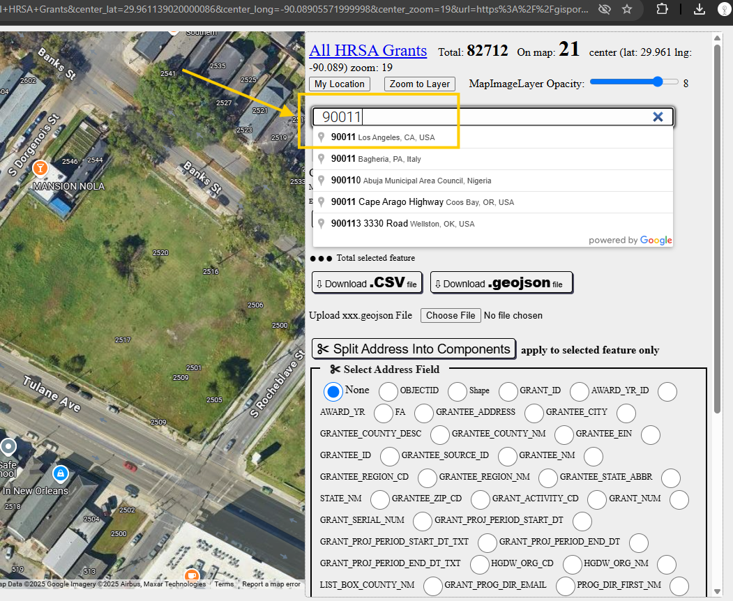
https://transparentgov.net/json2tree/esri/server/folder2.html?org=https%3A%2F%2Fgisportal.hrsa.gov%2Fserver%2Frest%2Fservices&url=https%3A%2F%2Fgisportal.hrsa.gov%2Fserver%2Frest%2Fservices&select_folder=85&select_layer=0&arcgis_online_token=&select_folder_text=Grants+%3Csup%3EMapServer%3C%2Fsup%3E&select_layer_text=0+%26%23x21E2%3B+All+HRSA+Grants+%3Csup%3EFeature+Layer%3Csub%3E+esriGeometryPoint%3C%2Fsub%3E%3C%2Fsup%3E

Step 2.
model 6803
https://transparentgov.net/json2tree/gateway/google/square-add-geojson-split-address.html?layer_id=0&layer=All+HRSA+Grants¢er_lat=34.048840657116656¢er_long=-118.27350724503141¢er_zoom=13&url=https%3A%2F%2Fgisportal.hrsa.gov%2Fserver%2Frest%2Fservices%2FGrants%2FGrants%2FMapServer&panto=0&location=Los+Angeles%2C+CA+90011%2C+USA
Step 3.
choose file upload los angeles county 200 cities boundary geojson file( I download previously from another model tool)
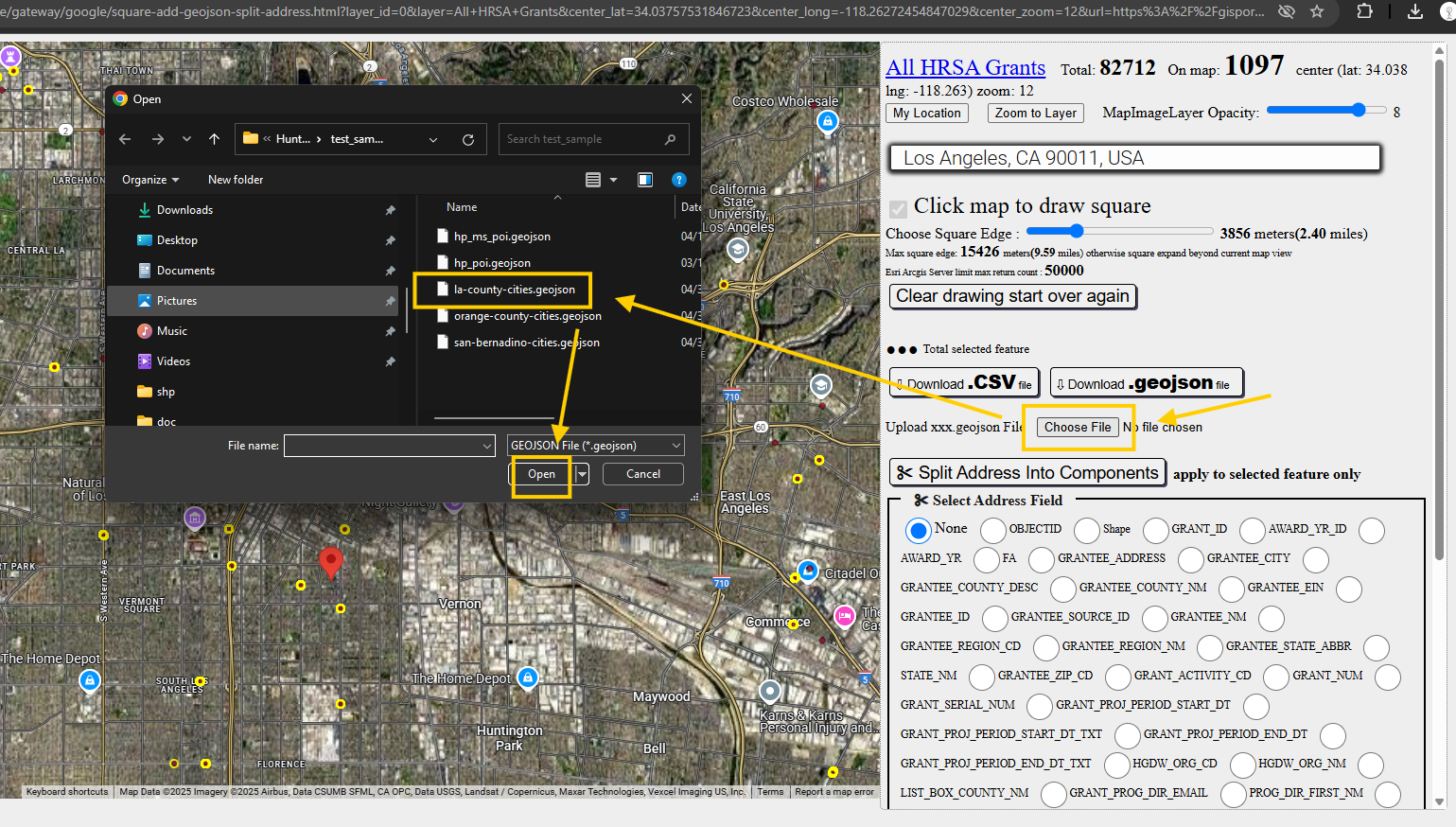
Step 4.
yellow line are los angeles county 200 cities boundary, click along a boundary you wanted to draw red square, which select point becomes blue. not selected point by default is yellow.

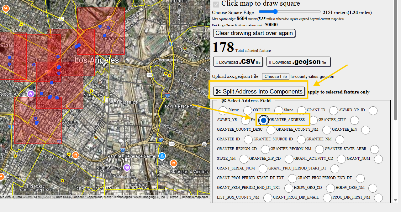
Step 5.
select which field is address field, that you want to split,
then click button to split it.
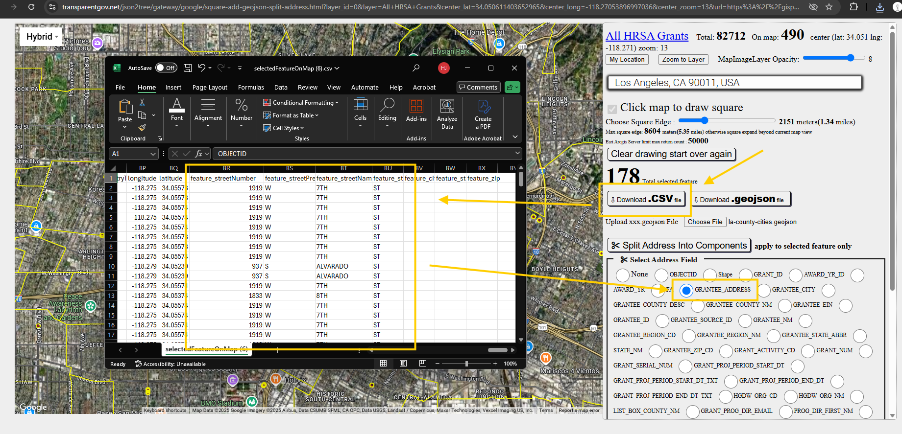
Step 6.
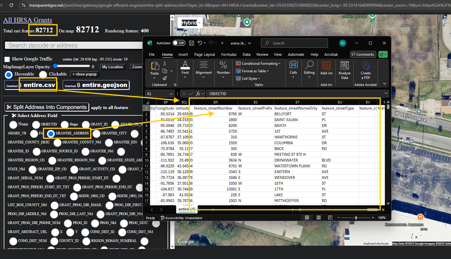
click download csv button, open csv file in excel, you can see now address field now split into street number, street name, street type, ...etc.
Step 7.
model 7455
https://transparentgov.net/json2tree/gateway/google-efficient-engine/entire-split-address.html?layer_id=0&layer=All+HRSA+Grants¢er_lat=29.655992510000026¢er_long=-95.53141646999994¢er_zoom=19&url=https%3A%2F%2Fgisportal.hrsa.gov%2Fserver%2Frest%2Fservices%2FGrants%2FGrants%2FMapServer&panto=0
instead of previous selected points, this model apply address split on entire layer, entire all points.
1st select with address field you want to split
2nd click split button
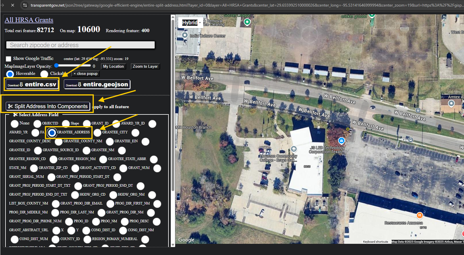
Step 8.
the whole layer have 82k address point, mormally a small city have 20-40k address point, this layer equals 4 small city address point.
click download entire csv button.
You will see address field was split into street number, street name, street type, city, zip etc....
Now police officer, 911 dispatch, general public, everyone, anyone can have access this privilege split address function