Step 1.
street locator has fake address, address locator don't. How to know a given locator is street based, or address based ?
How do you know it is old arcMap based ? or new ArcPro based ?
It is all in f=json file
https://gisapps.cityofchicago.org/arcgis/rest/services/AddressPoints/GeocodeServer?f=json
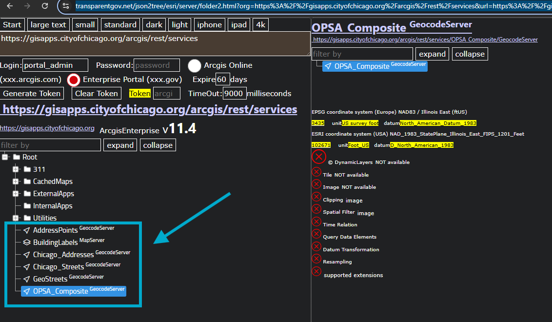
Step 2.
5 different locator here, which one should I use ? what is different ?
It is all in f=json file.
https://transparentgov.net/json2tree/esri/server/folder2.html?org=https%3A%2F%2Fgisapps.cityofchicago.org%2Farcgis%2Frest%2Fservices&url=https%3A%2F%2Fgisapps.cityofchicago.org%2Farcgis%2Frest%2Fservices&arcgis_online_token=&timeout=9000&select_folder=11&select_layer=-1&select_folder_text=OPSA_Composite+%3Csup%3EGeocodeServer%3C%2Fsup%3E&select_layer_text=OPSA_Composite+%3Csup%3EGeocodeServer%3C%2Fsup%3E
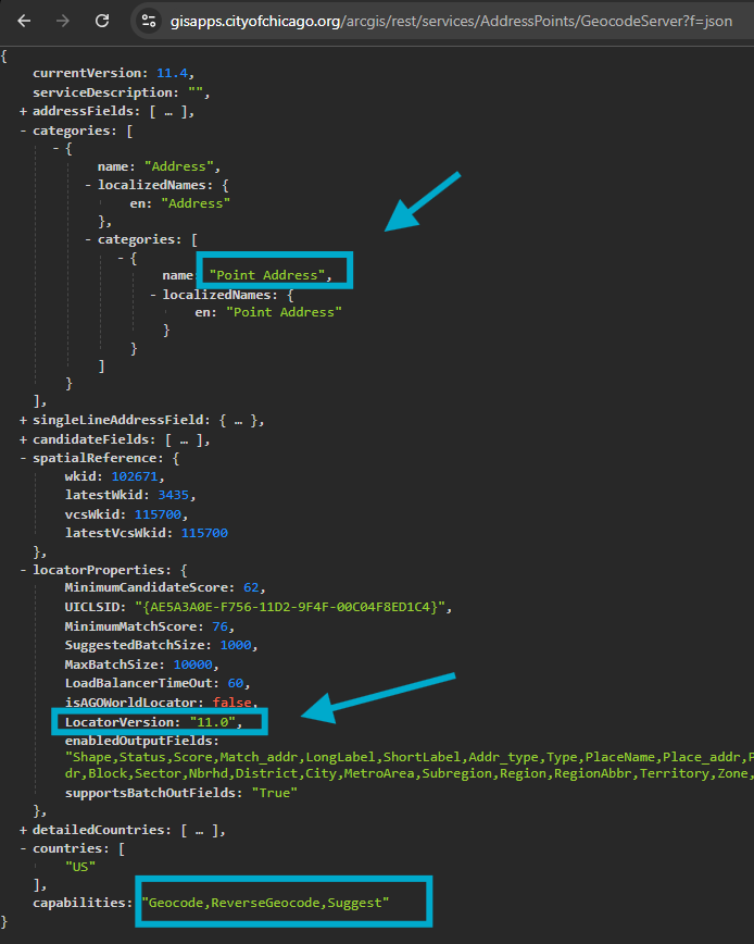
Step 3.
Here is f=json file sample,
The problem is f=json file is difficult to read, very difficult to understand, which means what
https://gisapps.cityofchicago.org/arcgis/rest/services/AddressPoints/GeocodeServer?f=json
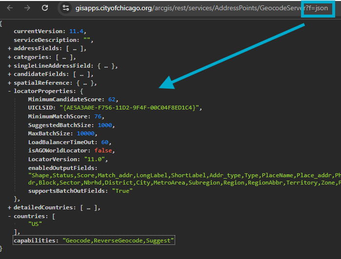
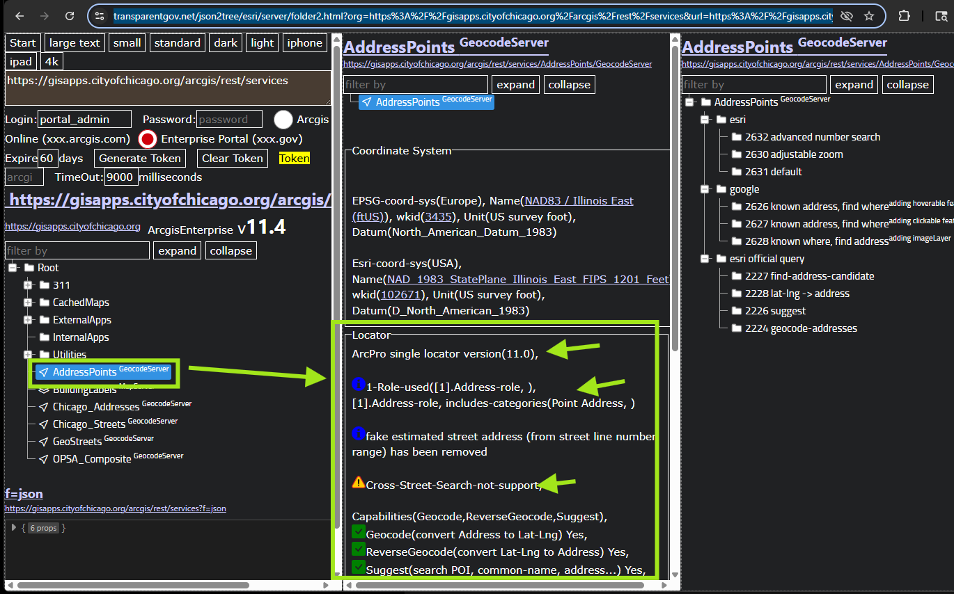
Step 4.
to make it easy to read, click each locator, the basic information about this locator popup like
so you will know each locator has different properties, different capabilities.
https://transparentgov.net/json2tree/esri/server/folder2.html?org=https%3A%2F%2Fgisapps.cityofchicago.org%2Farcgis%2Frest%2Fservices&url=https%3A%2F%2Fgisapps.cityofchicago.org%2Farcgis%2Frest%2Fservices&arcgis_online_token=&timeout=9000&select_folder=6&select_layer=-1&select_folder_text=AddressPoints+%3Csup%3EGeocodeServer%3C%2Fsup%3E&select_layer_text=AddressPoints+%3Csup%3EGeocodeServer%3C%2Fsup%3E
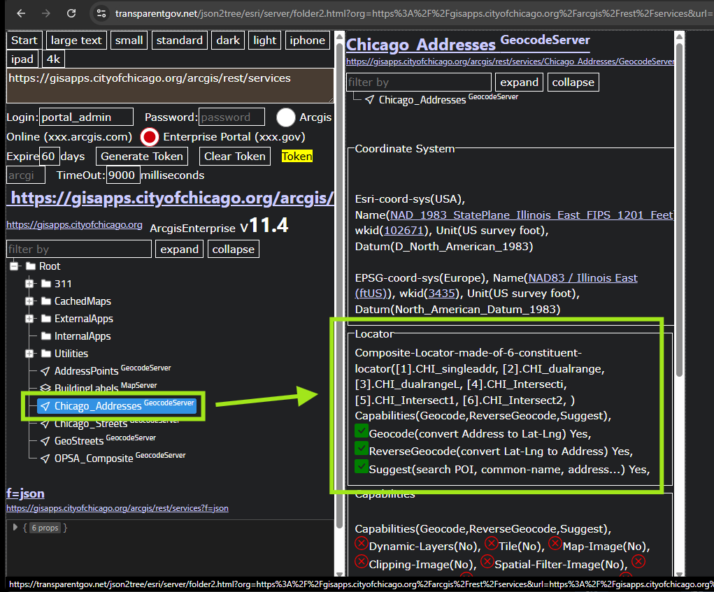
Step 5.
here is sample of composite locator made of 6 child locator
https://transparentgov.net/json2tree/esri/server/folder2.html?org=https%3A%2F%2Fgisapps.cityofchicago.org%2Farcgis%2Frest%2Fservices&url=https%3A%2F%2Fgisapps.cityofchicago.org%2Farcgis%2Frest%2Fservices&arcgis_online_token=&timeout=9000&select_folder=8&select_layer=&select_folder_text=Chicago_Addresses+%3Csup%3EGeocodeServer%3C%2Fsup%3E&select_layer_text=AddressPoints+%3Csup%3EGeocodeServer%3C%2Fsup%3E
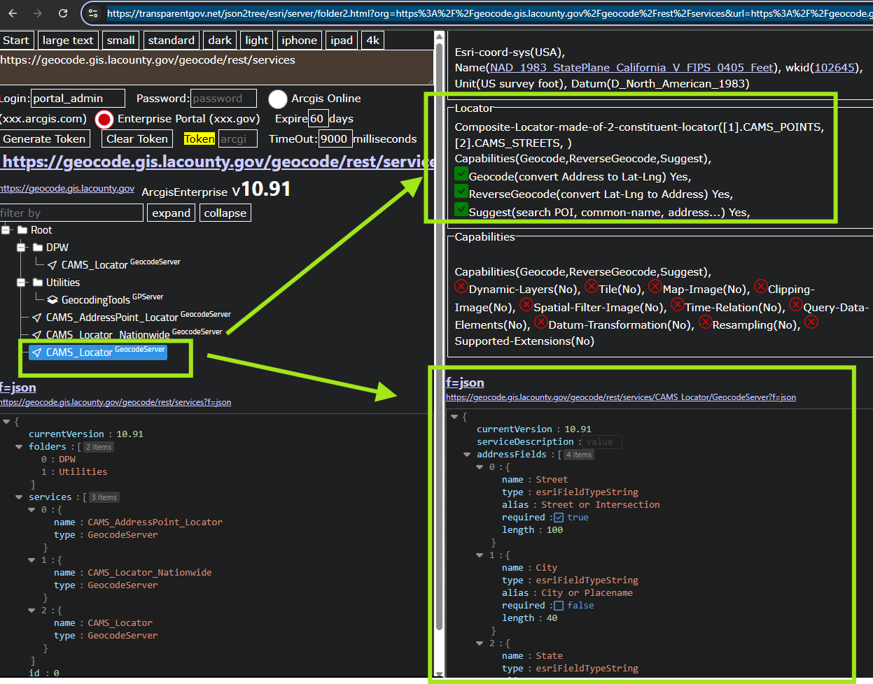
Step 6.
here is Los Angeles County cams locator, there are 5 of them, each locator has different function,
click each one to read its capability. Some can search cross street, some can't. Some made of point, some made of street line, or both.
Further more, you can directly view f=json file from here, it has full information.
https://transparentgov.net/json2tree/esri/server/folder2.html?org=https%3A%2F%2Fgeocode.gis.lacounty.gov%2Fgeocode%2Frest%2Fservices&url=https%3A%2F%2Fgeocode.gis.lacounty.gov%2Fgeocode%2Frest%2Fservices&arcgis_online_token=&timeout=9000&select_folder=5&select_layer=&select_folder_text=CAMS_Locator+%3Csup%3EGeocodeServer%3C%2Fsup%3E&select_layer_text=ProLocator_A+%3Csup%3EGeocodeServer%3C%2Fsup%3E
Step 7.
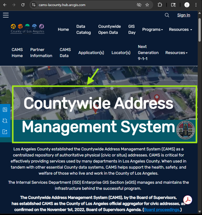
Los Angeles County established the Countywide Address Management System (CAMS)
Los Angeles County cams locator https://cams-lacounty.hub.arcgis.com/
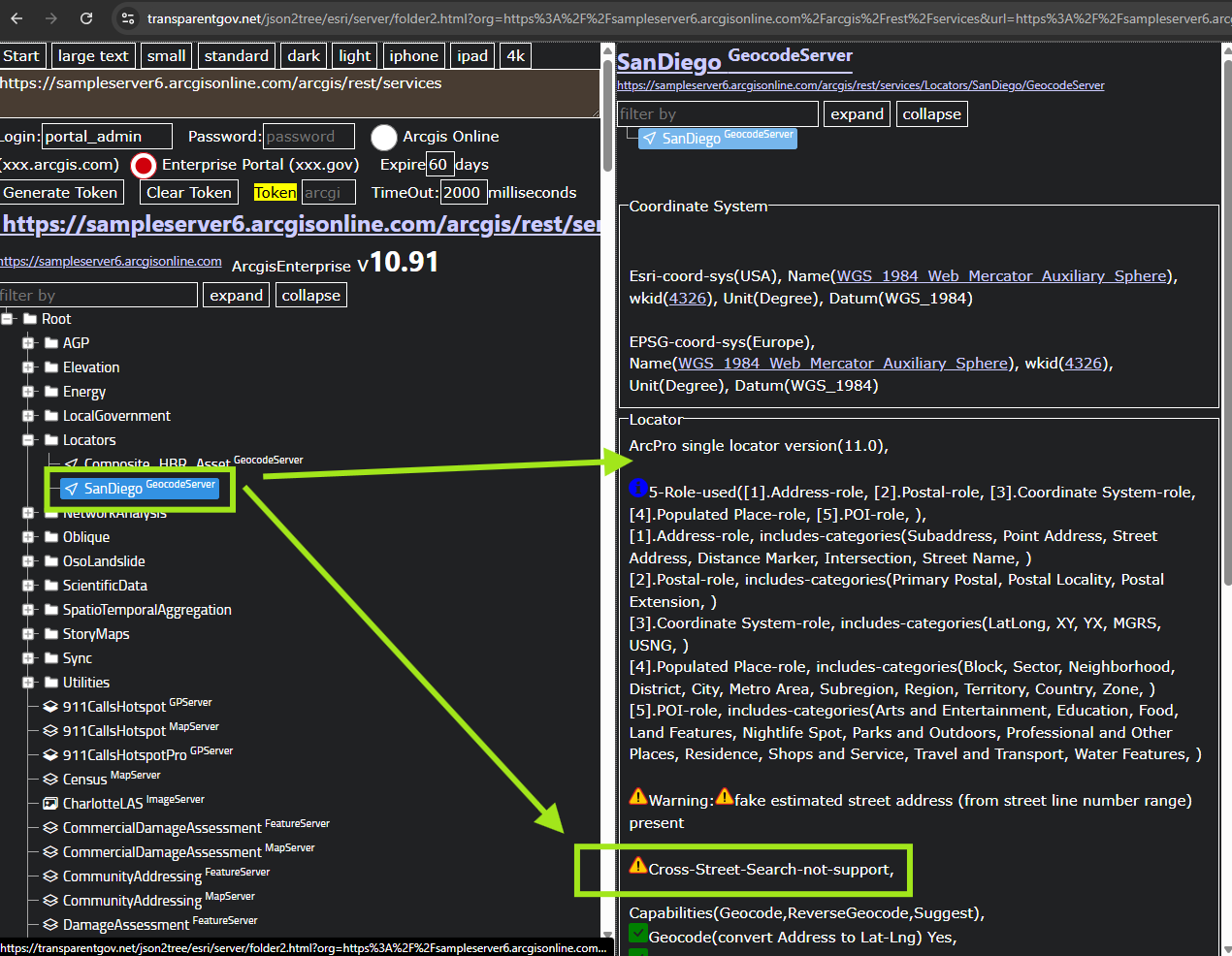
Step 8.
here is San Diego locator, warning, it does not support cross street name search !
https://transparentgov.net/json2tree/esri/server/folder2.html?org=https%3A%2F%2Fsampleserver6.arcgisonline.com%2Farcgis%2Frest%2Fservices&url=https%3A%2F%2Fsampleserver6.arcgisonline.com%2Farcgis%2Frest%2Fservices&arcgis_online_token=&select_folder=117&select_folder_text=SanDiego+%3Csup%3EGeocodeServer%3C%2Fsup%3E&select_layer=
Step 9.
Step 10.
Step 11.
Step 12.
Step 13.
Step 14.
Step 15.
Step 16.
Step 17.
Step 18.
Step 19.
Step 20.