Step 1.
LA county missing or wrong address rate estimated is 20% - 25%.
2 million x 20% = 400,000
To fix them manually in Arcgis Pro is not possible.
Drawing one address point in Arcgis Pro cost about 30 click and typing,
select editing tool, select point, draw, type address number, street name, zip code, prefix, street type, suffix, zip code, city name, save.
0.4 million x 30 click = 12 million click and typing,
This is not possible for human.
That is why LA county have not fix these address problem since 1990s.
Step 2.
To automate the process is possible in 2026.
The principle idea is
if 2 address have same house number, street name, street type, unit type and number, zipcode,
I can say these 2 address are identical.
Otherwise, they are different address.
if different, then add new address to repository, otherwise, skip it.
Computer can compare 2 million address and filter out which is new address, which is not.
Step 3.
For POI, if 2 POI have same name and street number,
I can say these 2 POI are identical,
otherwise, they are different.
if different, then add new POI to repository, otherwise, skip it.
Step 4.
address refiney tool can automatically compare 2 address,
automatically filter out duplicate address, only add new address to repository.
https://transparentgov.net/json2tree/esri/server/folder.html?org=https%3A%2F%2Fpublic.gis.lacounty.gov%2Fpublic%2Frest%2Fservices&url=https%3A%2F%2Fpublic.gis.lacounty.gov%2Fpublic%2Frest%2Fservices&arcgis_online_token=&timeout=9000&select_folder=18&select_layer=18&select_folder_text=Political_Boundaries+%3Csup%3EMapServer%3C%2Fsup%3E&select_layer_text=18+%26%23x21E2%3B+County+Boundaries+%3Csup%3EFeature+Layer%3Csub%3E+esriGeometryPolygon%3C%2Fsub%3E%3C%2Fsup%3E
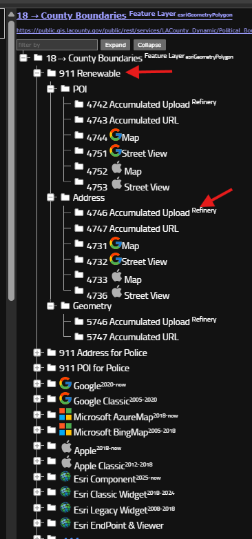
Step 5.
Arcgis pro do not have such specialized tool
Even they have, requires ESRI license.
Geojson based tool here is free to public, no license required.
always select latest address first,
https://transparentgov.net/json2tree/esri/vendor/refinery/addr-upload.html
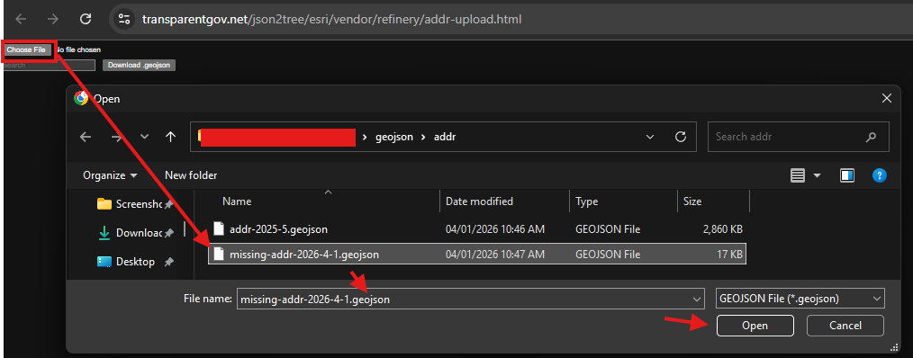
Step 6.
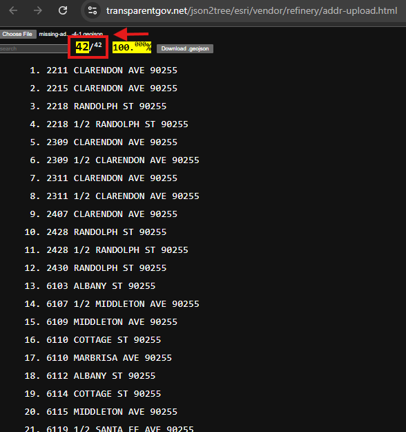
the lastest address patch have 42 address.
Step 7.
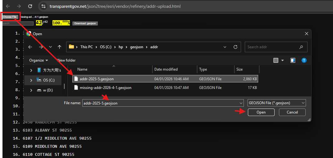
now load older address data,
old address will combine with new data based on the rules I mentioned earlier.
If duplicate, then skip, if new, then added to total.
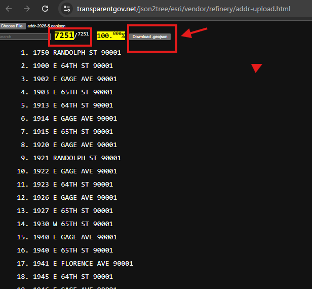
Step 8.
new total is 7251, which include old address and new address in 2 different files.
now you can upload more address patch, combine to repository.
click download geojson button,
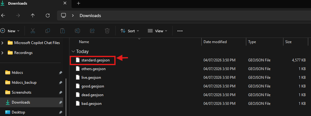
Step 9.
the new download file, standard.geojson
is combination of multiple address patch.
Step 10.
This is a proof of concept test.
In theory, you can get 188 cities address in small address patchs
or each zipcode is a address patch.
90001-2026.geojson, 90002-2026.geojson, and so on.
Next year, some address changed,
You get another 90001-2027.geojson, 90002-2027.geojson,
Next 5 years, you get a few new address patch by city name,
Vernon-2030.geojson.
south-gate-2032.geojson.
No matter what year, what area, address patch you get, you can combine it with
your existing repository by using this tool.
Step 11.
Everytime you combine a new latest address patch,
you always have latest address repository for LA county.
Then the next question is
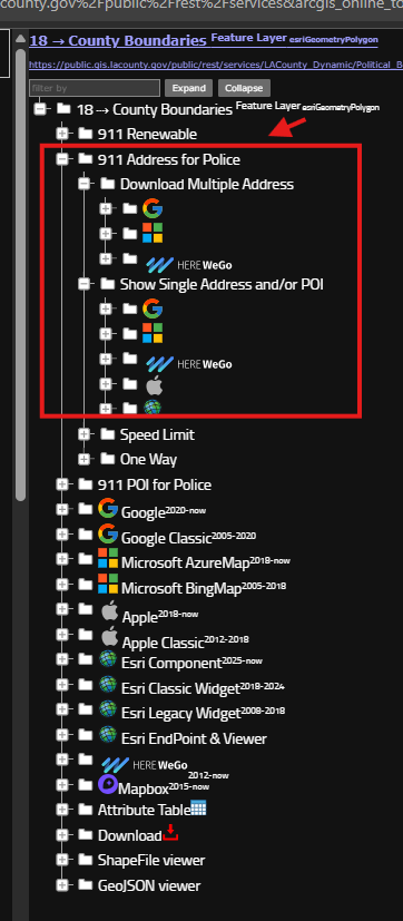
where you can get these address patch ?
it is here, use these tools to get address patch.
https://transparentgov.net/json2tree/esri/server/folder.html?org=https%3A%2F%2Fpublic.gis.lacounty.gov%2Fpublic%2Frest%2Fservices&url=https%3A%2F%2Fpublic.gis.lacounty.gov%2Fpublic%2Frest%2Fservices&arcgis_online_token=&timeout=9000&select_folder=18&select_layer=18&select_folder_text=Political_Boundaries+%3Csup%3EMapServer%3C%2Fsup%3E&select_layer_text=18+%26%23x21E2%3B+County+Boundaries+%3Csup%3EFeature+Layer%3Csub%3E+esriGeometryPolygon%3C%2Fsub%3E%3C%2Fsup%3E
Step 12.
Step 13.
Step 14.
Step 15.